


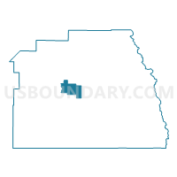
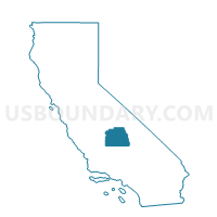
Voting District 10640, Tulare County, California
About
Outline

Summary
| Unique Area Identifier | 545324 |
| Name | Voting District 10640 |
| County | Tulare County |
| State | California |
| Area (square miles) | 66.12 |
| Land Area (square miles) | 66.12 |
| Water Area (square miles) | 0.00 |
| % of Land Area | 100.00 |
| % of Water Area | 0.00 |
| Latitude of the Internal Point | 36.26642010 |
| Longtitude of the Internal Point | -118.95105090 |
Maps

Graphs
Select a template below for downloading or customizing gragh for Voting District 10640, Tulare County, California


Neighbors
Neighoring Voting District (by Name) Neighboring Voting District on the Map
- Voting District 10590, Tulare County, CA
- Voting District 10655, Tulare County, CA
- Voting District 10720, Tulare County, CA
- Voting District 10750, Tulare County, CA
- Voting District 11195, Tulare County, CA
- Voting District 54900, Tulare County, CA
- Voting District 55740, Tulare County, CA
Top 10 Neighboring County Subdivision (by Population) Neighboring County Subdivision on the Map
- Woodlake-Three Rivers CCD, Tulare County, CA (13,168)
- Springville-Johnsondale CCD, Tulare County, CA (5,615)
Top 10 Neighboring Elementary School District (by Population) Neighboring Elementary School District on the Map
- Exeter Union Elementary School District, CA (13,492)
- Strathmore Union Elementary School District, CA (5,590)
- Springville Union Elementary School District, CA (3,797)
- Three Rivers Union Elementary School District, CA (2,266)
- Sequoia Union Elementary School District, CA (2,079)
Top 10 Neighboring Secondary School District (by Population) Neighboring Secondary School District on the Map
- Porterville Unified (9-12) School District, CA (47,072)
- Exeter Union High School District, CA (16,293)
- Woodlake Union High School District, CA (12,614)
Top 10 Neighboring Unified School District (by Population) Neighboring Unified School District on the Map
Top 10 Neighboring State Legislative District Lower Chamber (by Population) Neighboring State Legislative District Lower Chamber on the Map
Top 10 Neighboring State Legislative District Upper Chamber (by Population) Neighboring State Legislative District Upper Chamber on the Map
Top 10 Neighboring 111th Congressional District (by Population) Neighboring 111th Congressional District on the Map
Top 10 Neighboring Census Tract (by Population) Neighboring Census Tract on the Map
Top 10 Neighboring 5-Digit ZIP Code Tabulation Area (by Population) Neighboring 5-Digit ZIP Code Tabulation Area on the Map
- 93247, CA (17,423)
- 93221, CA (14,945)
- 93267, CA (6,237)
- 93265, CA (3,699)
- 93271, CA (2,276)
- 93244, CA (534)